טעקע:India Rajasthan locator map.svg

בילד מיט אַן הױכע רעזאָלוציע (טעקע SVG, נאמינעל: 1,574 × 1,738 פיקסעלן, טעקע גרייס: 836 קילאבייטן)
| טיטל |
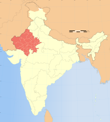
Rajasthan locator map |
|||||||||
| תיאור |
Locator map of the state of Rajasthan, India with district boundaries. |
|||||||||
| דאַטע | ||||||||||
| מקור |
אייגענע אַרבעט |
|||||||||
| יוצר |
|
|||||||||
| דערלויבעניש (ווײַטערניצן די דאָזיגע טעקע) |
אני, בעל זכויות היוצרים על עבודה זו, מפרסם בזאת את העבודה תחת הרישיון הבא: די טעקע ווערט ליצענצירט אונטער דער Creative Commons Alike 3.0 Unported ליצענץ.
|
|||||||||
| Geotemporal data | ||||||||||
| תאריך מתואר | במחצית השנייה של המאה ה-20 ו- המאה ה-21 | |||||||||
| Spatial reference system | conic | |||||||||
| Bounding box |
|
|||||||||
| Georeferencing | If inappropriate please set warp_status = skip to hide. | |||||||||
| Archival data | ||||||||||
| הערות | Part of WikiProject India Maps | |||||||||
| אַנדערע ווערסיעס |
|
|||||||||


- Error in {{Map}} template: unknown parameter "legend__galaberi_barmer".
Notes
Depiction of India's borders
- The territorial boundaries of India are shown as per the actual ground situation in accordance with international practices followed by the United Nations ([1], [2]) and the National Geographic Society ([3], [4])
- This map is meant to be for illustrative purpose only and is not authenticated by official government sources. Please check the list of sources and references used to create the map for a measure of accuracy and verifiability.
- The usage of these maps in India, Pakistan and China are governed by different laws that restrict depictions of boundaries other than what is officially recognized by the state. Please check local laws and modify the map accordingly before use.
Explanation of disputed boundaries


- Boundary of Indian claim : The territory India claims is legally theirs, but the claim is disputed by China and Pakistan.
- Line of Control/Line of Conflict : The de facto administrative boundary recognised by the international community. This UN ceasefire line is considered as a temporary solution to an ongoing conflict since the departure of the British Raj.
Borders of disputed regions
The depicted extent of the former territory of the British Indian Empire, succeeded by Republic of India, may not be accepted by few countries as legal due to ongoing border disputes:
- The northern Himalayan region of the disputed territory Indian-administered Kashmir is claimed by India including (Pakistan-administered Kashmir) and the Chinese-occupied territory of (Ladakh plateau). Since 1972, it is divided between all three countries. See also Line of Control and Line of Actual Control.
- Siachen glacier (shown white) is an actively contested region between India and Pakistan. Since 1984, the region is under Indian control.
- The northeastern territory of Arunachal Pradesh is almost entirely claimed by China as part of its Tibetan territory.
- Minor areas of eastern Kashmir's Ladakh division, Himachal Pradesh and Uttarakhand on the Chinese frontier are claimed by China. These areas are under Indian control.
- A small area of Uttarakhand adjoining the Nepal border along the Sarda river is disputed between the two countries.
For a detailed map of all disputed regions in South Asia, see Image:India disputed areas map.svg
Internal borders
The borders of the state of Meghalaya, Assam and Arunachal Pradesh are shown as interpreted from the North-Eastern Areas (Reorganisation) Act, 1971, but has yet to be verified.
Territorial waters
The limit of the territorial waters of India extends to twelve nautical miles measured from the appropriate baseline. See this for more information.
היסטאריע פֿון דער טעקע
קליקט אויף א דאטע/צײַט צו זען דאס בילד אזוי ווי עס איז דעמאלסט געווען
| דאַטע/שעה | געמינערטע בילד | געמעסטן | באניצער | קאָמענטאַר | |
|---|---|---|---|---|---|
| איצטיקע | 07:16, 29 דעצעמבער 2008 | | 1,738 × 1,574 (836 קילאבייטן) | Planemad | {{Information |Description= |Source= |Date= |Author= |Permission= |other_versions= }} |
| 17:43, 6 אויגוסט 2006 |  | 1,852 × 1,639 (751 קילאבייטן) | Planemad | {{WikiProject_India_Maps |Title=Rajasthan locator map |Description=Locator map of the state of Rajasthan, India with district boundaries. |Source=. |Date=August 6 2006 |Author=w:user:Nichalpw:user:Planemad |Thumbdir=CHANGE }} |
טעקע באַניץ
דער פאלגנדער בלאט ניצט די דאזיגע טעקע:
גלאבאלע טעקע־פארווענדונג
די פאלגנדע אנדערע וויקיס ניצן די דאזיקע טעקע:
- באניץ ביי as.wikipedia.org
- באניץ ביי ba.wikipedia.org
- באניץ ביי be-tarask.wikipedia.org
- באניץ ביי be.wikipedia.org
- באניץ ביי bg.wikipedia.org
- באניץ ביי bh.wikipedia.org
- באניץ ביי bn.wikipedia.org
- বালি, রাজস্থান
- নোখা
- ১ এসজিএম
- ছাবরা
- ছাপার
- ছিপাবারোদ
- ছোটি সাদ্রি
- চিরাওয়া
- চিতোরগড়
- চোমু
- চুরু
- দারিবা, রাজস্থান
- আলোয়ার
- দৌসা
- ডিগ (রাজস্থান)
- দেশনোকে
- দেবগড়, রাজস্থান
- ধারিয়াওয়াদ
- ঢোলপুর
- আবু সড়ক
- দিদওয়ানা
- দুঙ্গারগড়
- দুঙ্গারপুর
- ফতেহনগর
- ফতেহপুর
- আমেত
- গজসিংহপুর
- গালিয়াকোট
- শ্রীগঙ্গানগর
- গঙ্গাপুর (ভিলওয়ারা)
- গঙ্গাপুর সিটি
- গোরেডি চাঁচা
- গোথারা
- গুলাবপুরা
- হনুমানগড়
- হিন্দাউন
- ইন্দ্রগড়
- জাহাজপুর
- জয়সলমের
- জয়তারান
- জালোর
- ঝালাওয়াড়
באקוקן נאך גלאבאלן באניץ פון דער טעקע.