טעקע:Han foreign relations CE 2 chinese.jpg
בילד מיט אַן הױכע רעזאָלוציע (965 × 650 פיקסעל, טעקע גרייס: 530 קילאבייטן, טיפ MIME: image/jpeg)
- Chinese language version of "Map of Han foreign relations in CE 2"
Introduction
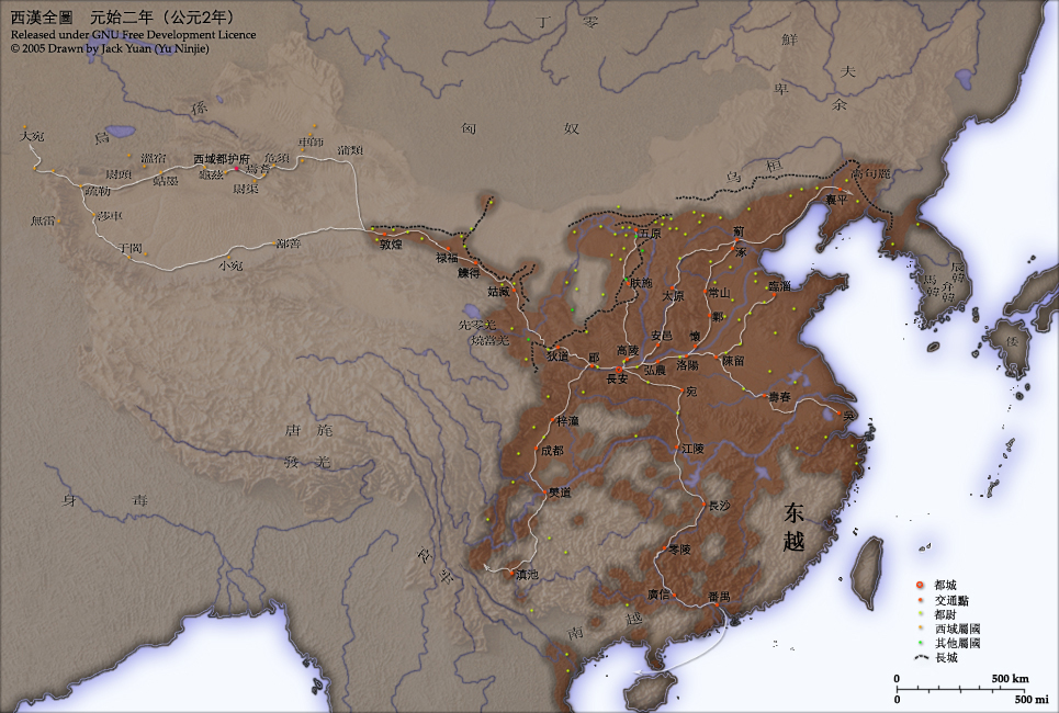
This map shows the world as was known to Han Dynasty China in CE 2. Names of non-Chinese peoples and states have been purposely left with their Chinese names (e.g. Dayuan instead of Fergana; Gaogouli instead of Goguryeo) to reflect the fact that our knowledge of participants in the Han world order comes almost exclusively from Chinese sources.
- Credits
- Chinese Version of Image:Han foreign relations CE 2.jpg.
- Created and copyright (2005) by Yu Ninjie.
- Released under the GNU FDL.
Territorial garrisons
The headquarters of chief commandants (都尉) are shown in yellow. Chief commandants commanded territorial garrisons and were responsible for the supression of local armed threats and supervision of recruitment for military service. Note that these were concentrated on the frontiers, especially on the northern border region. When in the interior of the Han empire, they were often placed near iron or salt industries, or on important communication routes. A few dependent states (屬國) are shown in green. These were usually mixed settlements of Chinese and Xiongnu or more commonly, Qiang, under Han administration.
The Great Wall
During most of the Western Han period, the Great Wall served as a line of demarcation between Han and non-Chinese peoples, most notable of whom were the Xiongnu. The line of the Great Wall was extended by Emperor Wu along the Gansu corridor (the commanderies based at Dunhuang, Lufu, Lude and Guzang). This, along with walls north of the great loop of the Yellow River (beyond Wuyuan), provided the front line defences against the Xiongnu. A second line was maintained along the old Qin wall (the one that passes close to Fushi and Didao), which was important even into the 1st century CE.
Both the lines of the Great Wall and Yellow River are based on Tan Qixiang (ed.), Zhongguo lishi ditu (中国历史地图集), 1982. Note that the Yellow River is considerably to the north of its present flow.
Routes of communication
The broad outline of communication and transport routes from the capital Chang'an is marked in white. These were based on Qin Dynasty imperial highways, Han roads (such as the Chang'an-Anyi-Taiyuan-Yu road) and navigable riverways (such as the Chenliu and Shouchun river routes). The long road, often known as the Silk Road, extended west from Chang'an to the "Western Regions".
These are based in part on the reconstruction of early Chinese roads and waterways by Joseph Needham in Science and Civilisation, Vol. IV, 1954-, and the additions of Rafe de Crespigny in Generals of the South, 1992. The northern and southern routes of the Silk Road in the Western Regions is based on Map 16 in Cambridge History of China, vol. 1, 1986.
The Western Regions
From the end of the 2nd century CE, Han China fought with the Xiongnu over control of the "Western Regions". By the time that they established the office of Protector General of the Western Regions (at Wulei) in 60 BCE or 59 BCE, the entire region was dominated by the Chinese. Tributary city-states, in light orange, sent periodic tribute to Chang'an and were rewarded by the Han court.
License and Source

|
מען גיט רשות צו קאפירן, פארשפרייטן אדער מאדיפיצירן דעם דאקומענט, לויט די באדינגונגען פונעם גנו פֿרייען דאקומענטאציע ליצענץ, ווערסיע 1.2 אדער א שפעטערע ווערסיע פארעפנטלעכט דורכן פרייע ווייכווארג פונדאציע; מיט קיין אומפארענדערלעכע פאראגראפן, און קיין פאדערשטע אדער הינטערשטע דעק טעקסטן. א קאפיע פונעם ליצענץ איז איינגעשלאסן אינעם אפטייל גנו פֿרייער דאקומענטאציע ליצענץ. |
| די טעקע ווערט ליצענצירט אונטער דער Creative Commons Alike 3.0 Unported ליצענץ. | ||
| ||
| תבנית רישוי זו הוספה לקובץ כחלק מעדכון רישיון GFDL. |
- Source
- Chinese Wikipedia, original upload 2005年4月7日 (木) by Yu Ninjie
היסטאריע פֿון דער טעקע
קליקט אויף א דאטע/צײַט צו זען דאס בילד אזוי ווי עס איז דעמאלסט געווען
| דאַטע/שעה | געמינערטע בילד | געמעסטן | באניצער | קאָמענטאַר | |
|---|---|---|---|---|---|
| איצטיקע | 03:37, 25 יוני 2009 | | 650 × 965 (530 קילאבייטן) | KEIMS | add a name |
| 09:29, 13 דעצעמבער 2005 |  | 650 × 965 (516 קילאבייטן) | Shizhao | ||
| 02:51, 4 אָקטאָבער 2005 |  | 650 × 965 (558 קילאבייטן) | Saperaud~commonswiki | Chinese Version of Image:Han foreign relations CE 2.jpg. Created and copyright (2005) by Yu Ninjie. Released under the GNU FDL. This map shows the world as was known to Han Dynasty China |
טעקע באַניץ
דער פאלגנדער בלאט ניצט די דאזיגע טעקע:
גלאבאלע טעקע־פארווענדונג
די פאלגנדע אנדערע וויקיס ניצן די דאזיקע טעקע:
- באניץ ביי av.wikipedia.org
- באניץ ביי azb.wikipedia.org
- באניץ ביי incubator.wikimedia.org
- באניץ ביי ja.wikipedia.org
- באניץ ביי rue.wikipedia.org
- באניץ ביי ru.wikipedia.org
- באניץ ביי th.wikipedia.org
- באניץ ביי wikimania2006.wikimedia.org
- באניץ ביי zh-classical.wikipedia.org
- באניץ ביי zh-min-nan.wikipedia.org
- באניץ ביי zh.wikipedia.org